
Territorial Analysis and Management
Tools to assist in Territorial Development
THE CHALLENGES
Re-desining our territories
in response to climate change
Today, rural, sub urban and urban communities face numerous challenges, particularly due to shifting demographics and the impacts of climate change. These include the loss of biodiversity and the increased frequency and intensity of heatwaves and other extreme weather events, which pose significant risks to human health.
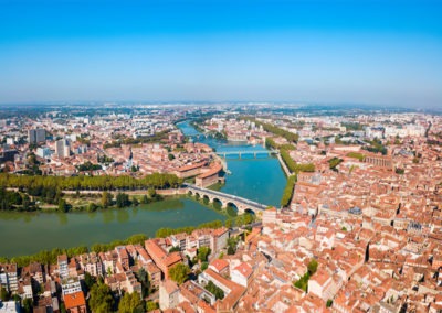
Urban areas are especially susceptible to these climate challenges, necessitating a reevaluation of their management practices while safeguarding resources and economic viability. This entails implementing resilient development strategies, reducing urban sprawl, and reintroducing green spaces.
In light of these pressing needs, TerraNIS offers specialized expertise to support sustainable and resilient urban development efforts.


OUR SOLUTION
With Landia, create a
portrait of your territory
To meet the needs of communities regarding territorial planning and sustainable development, TerraNIS developed the Landia solution. More than just a technical mapping tool, Landia is a diagnostic, analysis, evaluation, and decision support tool for managing your territories. We approach the topic of planning from various angles:
- Urban Vegetation
- Urban Climatology
- Soil Sealing
- Natural, Agricultural, and Forest Areas
Municipalities, administration, land planners, consulting firms, or experts, discover how Landia can help you design and manage the territory of tomorrow.
PROCESS
How does
Landia work?

THEME #1
Monitoring of urban vegetation
and the quality of life of residents
Urban vegetation is a key element in improving the quality of life for city dwellers and maintaining ecological balances. It plays a fundamental role in the urban ecosystem, improving ecological processes and human health. With Landia, we support local authorities in their ecological transition and in the reconquest of biodiversity in cities. Our indicators allow for the study of vegetation factors that influence the living environment of residents and facilitate the definition of public urban planning policies.
THEME #2
Analysis of urban climatology
and identification of heat islands
Territories are increasingly affected by the urban heat island phenomenon, leading to an increase in temperatures within the city compared to neighboring rural areas. The impacts on the population are significant: reduction in thermal comfort and health risks in the event of heatwaves. By relying on the morphological characteristics of the urban fabric and socio-demographic data, we highlight the vulnerability of populations to heatwaves exacerbated by the urban heat island effect.
THEME #3
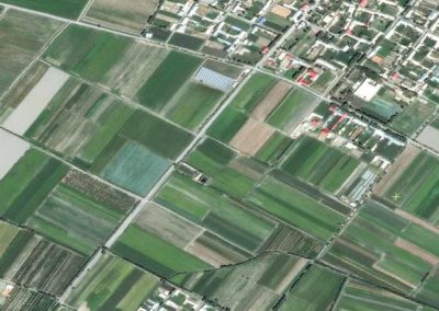
Mapping, analysis, and monitoring
of territorial artificialization
The urbanization of territories since the early 20th century has led to significant land consumption. Yet, soil artificialization has serious environmental consequences, and this phenomenon is now considered one of the primary causes of biodiversity collapse. Regulations now require the renaturing of spaces where possible, and land use frugality has become a national priority. Landia allows communities to analyze and monitor soil artificialization and make planning choices with thematic maps and indicators.
THEME #4
Mapping and monitoring of natural,
agricultural, and forest spaces
Natural, agricultural, and forest spaces are key elements for territories and fulfill many economic, social, and environmental functions. TerraNIS provides communities with an operational tool to monitor and characterize these natural, agricultural, and forest spaces using Earth observation images and land use data. The tool allows, for example, to detect and characterize hedge areas in a territory, map the green and blue infrastructure, and also identify agricultural and forest spaces.
OUR CLIENTS
They trust us,
how about you?

Our Landia tool has also been exported beyond our borders:

FOR WHOM?
Benefits at all levels
for territorial planning
LOCAL AUTHORITIES
Diagnosis and analysis of the plant heritage within the territory;
Implementation and evaluation of revegetation policies ;
Citizen engagement and support for discussion with elected officials.
PLANNERS AND STUDY OFFICES
Integration of data into development plans ;
Risk reduction by identifying at-risk or vulnerable areas;
Planning simulation according to constraints and resources.
ENVIRONMENTAL ASSOCIATIONS
Raising public and political decision-makers’ awareness of the importance of urban vegetation;
Participation in conservation projects and implementation of sustainable solutions for cities.
CONTACT
Would you like to test a
Landia service in your territory?
OUR PROJECTS
News from TerraNIS
projects & new developments
A lot is happening at TerraNIS! Discover below the current projects and new features of our services.