Satellite Imagery for Sustainable Development

Decision-support services for the ecological transition and regional adaptation to climate change

OUR ACTIVITIES

Geospatial services for a 
more sustainable world

For the past 10 years, TerraNIS has been developing Earth observation tools for the agricultural, viticultural, environmental and territorial sectors. Thanks to our expertise in spatial data, we are working to support the agro-ecological transition in agriculture and the resilience of towns and territories to the impacts of climate change.

Our mission? To provide decision-support tools and services to farming communities and stakeholders, helping them to optimize the use of natural resources and prepare for tomorrow’s climate challenges. Our passionate, multi-themed team designs and develops TerraNIS products on a daily basis, and offers tailor-made support to meet your needs.

OUR BUSINESS SECTORS

Earth Observation
for Agriculture & Territories

We design and operate Earth observation tools in various fields related to the living world. Cooperatives, winegrowers, communities: find out more about our range of services.
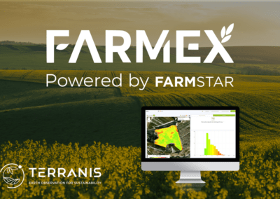
Precision Farming

Irrigation management, crop development monitoring and use of intermediate cover crops

Precision Viticulture

Optimizing harvests, reducing inputs, detecting water stress and monitoring planters
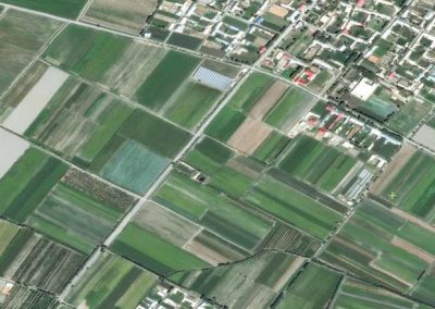
Land Management

Mapping the urban green grid, assessing residents’ comfort and identifying heat islands

Forests

Characterization of tree species, detection of burnt forest areas and regeneration monitoring

OUR AMBITION

To support those committed to
our agriculture and our territories

Our services must not only contribute to a collective awareness of the issues at stake, but also provide the means to define future changes in practices and policies. TerraNIS’ ambition is twofold:

  • On the one hand, we want to provide tools for the development of an agriculture capable of fulfilling its vital production missions while preserving natural resources as much as possible, in order to guarantee its sustainability.
  • On the other hand, we want to help build urban and rural living environments that can both respond to demographic change and ensure a healthy, pleasant quality of life.

USE CASE

Mapping of hedges, groves, and isolated trees in the Champagne Appellation to promote biodiversity in the vineyard

TerraNIS was called upon by the Comité Interprofessionnel du Vin de Champagne (CIVC) to map hedges, groves, and isolated trees across the Champagne Appellation (approximately 34,000 ha). We have thus extracted all the hedges, groves, and isolated trees through a thresholding method, complemented by an artificial intelligence approach. The maps created from these data have allowed us to assess the level of biodiversity of the Champagne vineyard and study its ecological continuities.

USE CASE

Production of Oenoview® maps to adapt the fertilization plan to the scale of the entire Moët & Chandon vineyard

Maison Moët & Chandon, founded in 1743, is the largest estate in the wine region with nearly 1,200 hectares of vines. Moët & Chandon has been using the Oenoview® service since 2019 to optimize the fertilization and harvest of its vines. TerraNIS produces Oenoview® maps from satellite imagery on all plots. Thanks to this solution, Maison Moët & Chandon has reduced its use of inputs to only use what is necessary for the proper development of its vines and is thus committing to a sustainable viticulture approach.

USE CASE

Identification of urban heat islands within the Montpellier Metropolis as part of the European Valorada project

The European Valorada project aims to provide data manipulation tools to European regions and communities in order to guide their adaptation strategies to climate change. In this context, TerraNIS produced a map of the heat islands of the Montpellier metropolis, thus making it possible to assess the vulnerability of populations to a heat wave aggravated by the UHI effect. This tool supports the metropolis in identifying the neighborhoods most vulnerable to heatwave episodes and implementing cooling strategies.

USE CASE

Standardizing Plots with Oenoview: A Successful Bet for Grands Chais de France Aquitaine

In 2016, the Grands Chais de France properties in Aquitaine decided to rely on the Oenoview expertise to improve yields and wine quality, which had been decreasing due to a succession of hot and dry vintages. A snapshot of the 300 ha of various properties was taken by the SPOT 7 satellite in August 2016. The Oenoview maps and data (measuring vigor and heterogeneity) obtained were then used to manage the fertilization across different vigor zones highlighted by the maps.

USE CASE

Euralis Supports Its Members with Irrigation Recommendations

Water management is a critical issue for the agricultural sector. Euralis has embraced this challenge and supports farmers in better managing water resources, including through irrigation management. For the fourth consecutive year, the cooperative has been using our Pixagri tool with its members. Thanks to Pixagri, farmers and their advisors can access accurate, daily, and spatialized data for each of the plots: evapotranspiration, monitoring of vegetative development, water balance, and irrigation recommendations.

USE CASE

Mapping the Canopy and Green Roofs of the City of Paris

In 2023, TerraNIS supported the city of Paris in mapping the vegetation of its territory. A reproducible production method was developed in partnership with the local authorities and CNES to monitor the evolution of the vegetation cover. This reference of green surfaces and vegetation indices allows the city to monitor the actions implemented on the ground as part of its Canopy Plan. Another part of this study also involved mapping the green roofs throughout the city.

USE CASE

Grand Paris Seine Ouest: Identifying Heat and Cool Islands with Landia

Since May 2020, Grand Paris Seine Ouest (GPSO) has established the roadmap of the “Intelligent Territory” to implement and evaluate its Territorial Climate Air Energy Plan (PCAET). In 2022, GPSO chose the Landia solution to identify heat and cool islands within its 8 cities. Thus, Landia addresses the “Environment and Quality of Life” theme within the Intelligent Territory framework and action 3 of axis 2, aiming to reduce the vulnerability of territorial actors to climate risk.

USE CASE

Thiols Viewed from the Sky: Segmenting the Sauvignon Plots of Vendéole Vineyards

In 2019, Vendéole Vineyards called upon the Oenoview® service to improve the segmentation of Sauvignon plots and isolate a group of high-potential thiol parcels. Marc Duffo, technical manager, testifies: “The results obtained on the wines are very satisfactory, with marked differences in thiol expression between the two selected lots. Oenoview® is a decision-making tool complementary to the work of vineyard technicians, effective compared to more traditional selection methods, which has allowed the vineyard team to save time.”

SOME FIGURES

A bird’s-eye view of
our clients and our projects

COMMUNITIES SUBSCRIBING TO OUR SERVICES

HECTARES MONITORED BY OUR SERVICES

COUNTRIES WHERE WE DEPLOY OUR SERVICES

CUSTOMERS ALL OVER THE WORLD

OUR CLIENTS

They trust us,
how about you?